Another wintry mix is expected to turn into rain over the weekend, bringing moderate snow initially before transitioning to freezing rain and eventually plain rain. While areas like Southwest PA may not see much winter weather, regions farther north and east are likely to be affected.
The weather conditions are expected to shift, transitioning into plain rain on Saturday evening or Sunday morning, depending on your location. This change will occur as the low pressure system moves directly above us. The regions most likely to experience the heaviest snowfall from this storm are Southern Ontario, the Adirondacks, and Northern New England.
Snowfall rates exceeding half an inch per hour will result in the accumulation of slush on our roads Saturday afternoon. Let’s delve into the timing.
WINTER WEATHER TIMING
This Article Includes
Snow is expected to arrive in Northwest PA, specifically along and north of I-80, by late Saturday morning. The Pittsburgh Metro area may experience a brief period of snow before it transitions into rain. However, the snow will quickly spread into Central PA. According to some models, there might be a gap in precipitation in Southern PA. Therefore, areas near and north of I-80 are more likely to receive snow around 1:00 PM on Saturday.
As Saturday afternoon progresses, the snow will persist in North Central PA and extend into much of Eastern PA. At the same time, Central PA, particularly areas south of State College, will start transitioning to sleet and freezing rain.
The Canadian model indicates that there will be snow, particularly in the Lehigh Valley and Northeast Pennsylvania, at 5:00 PM on Saturday.
There could be a brief break in the rainfall on Saturday evening before additional precipitation arrives. Towards the late hours of Saturday or early Sunday morning, we expect freezing rain in areas above 1100 feet elevation. Although not depicted in the model below, locations like Williamsport, Bloomsburg, and the Wyoming Valley in NEPA are situated below that elevation and are likely to experience rain without freezing conditions.
The Canadian model depicts icy conditions in Central and NEPA during the early hours of Sunday, specifically at 1:00 AM. It indicates that the mountainous regions along I-80 and I-81 can expect icy conditions.
By Sunday morning, the temperature will rise above freezing throughout the entire state, putting an end to the threat of winter weather.
FIRST CALL ICE FORECAST FOR SATURDAY PM – SUNDAY AM
Ice accumulation of about a tenth to a quarter-inch is expected in Area A. This could result in untreated roadways becoming icy, making travel unsafe.
Ice accumulation between a twentieth and a tenth-inch is expected in Area B. This may lead to icy conditions on untreated roadways, particularly mountain roads.
Expect ice accumulation of about a hundredth to a twentieth of an inch in Area C. The ice will primarily build up on elevated surfaces, but caution is advised on mountain roads as they may become slippery.
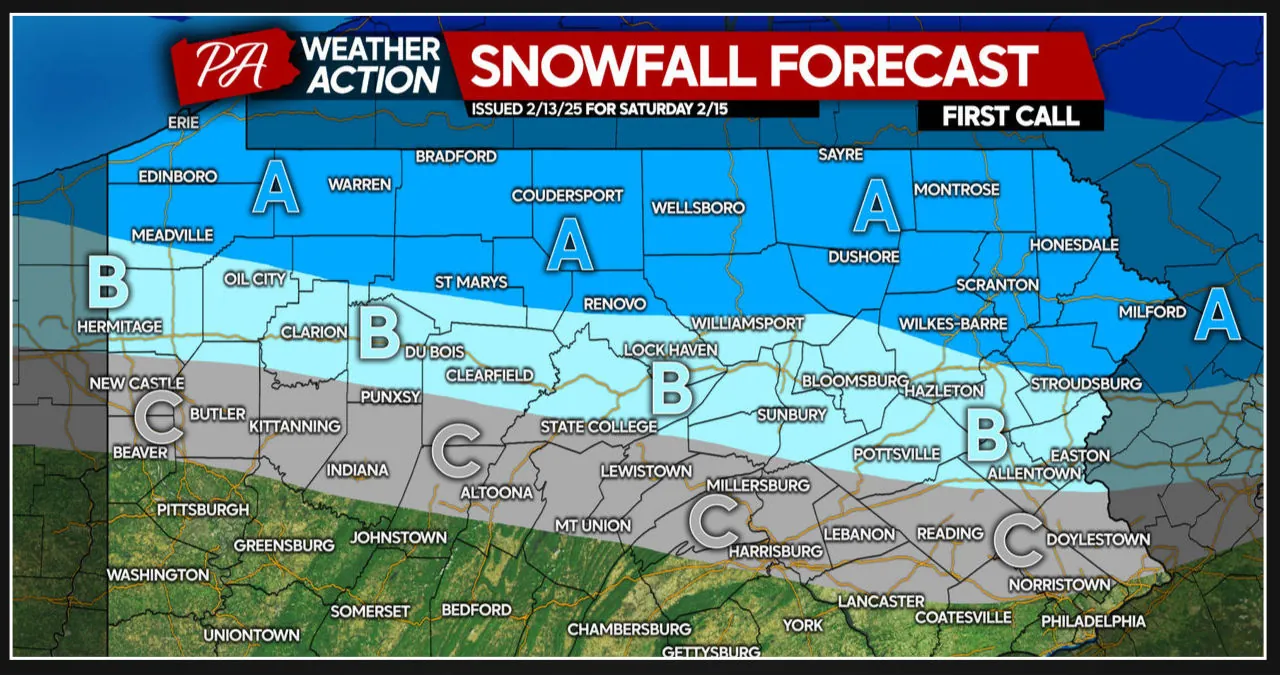
FIRST CALL SNOWFALL FORECAST FOR SATURDAY
Area A is expected to receive a snowfall accumulation of 2-4 inches. The roads in this area will be covered in snow and slush, making travel slippery.
Expect snowfall accumulation of 1-2 inches in Area B. The roads may become slushy during periods of heavier snow.
Area C: We are expecting less than 1″ of snowfall accumulation in this area. The roads are not expected to be affected by the snow.
Our Final Call Forecast will be released on Friday evening.