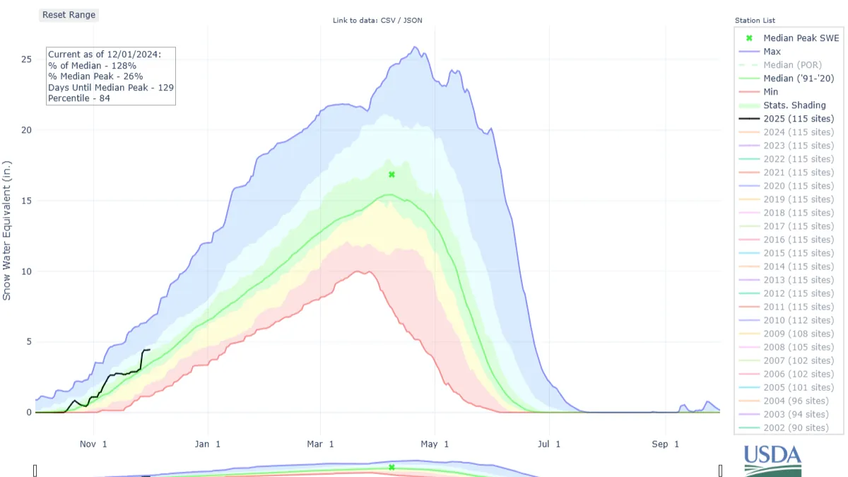
As meteorological winter begins, Colorado’s snowpack is already ahead of average levels, currently sitting 25-30 percentage points higher than usual for this time of year.
However, the coming week is expected to bring a prolonged period of drying and warming, causing some snow to melt, particularly on south-facing slopes. The next opportunity for snow looks to be between December 8 and 10.
A brief overview: Meteorological winter began on Sunday, but since Thanksgiving, no new snow has fallen, and none is expected in the coming days. High temperatures have gradually increased by one or two degrees per day since Thanksgiving.
The National Weather Service (NWS) in Boulder recorded a high of 27°F in Copper Mountain, while Aspen, according to the NWS in Grand Junction, reached 37°F.
The statewide snowpack has been steadily decreasing since Thanksgiving, dropping from 139% of average to 128% in just four days. It is expected to continue inching down, approaching 100% of the average.
While this decline may seem concerning, there are two key reasons it’s not overly worrisome. First, the sun’s angle is still gradually lowering as the winter solstice approaches in 19 days.
Second, daytime temperatures remain below freezing for most of the day, ensuring minimal snowmelt, especially on east and northwest-facing slopes.
Looking ahead, the forecast predicts a sunny, dry week in Colorado’s high country. From Monday to Sunday, high pressure will dominate the region, bringing clear skies and pleasant temperatures.
The NWS in Boulder predicts highs in the upper 30s at Copper Mountain, Winter Park, and Breckenridge, mid-40s in Aspen, and mid-30s in Crested Butte.
Longer-term models suggest no significant snowfall until Sunday morning, December 8, when snow showers are expected to begin in northern Colorado. The ECMWF forecast predicts these showers will mostly stay north of Interstate 70 until early Tuesday morning, December 10.
Early predictions indicate snow accumulations of 3-7 inches in northern mountains, 2-5 inches in central mountains, and 1-3 inches in the southern mountains, with the Sangre de Cristo Mountains also expecting 3-7 inches.
The first potential chance for fresh powder will be Monday, December 9, but forecasts will need to be refined over the coming days to provide more accurate estimates of snow totals and the storm’s overall impact.
Looking further ahead, a break in the snow is expected between Wednesday, December 11, and Thursday, December 12, before another storm system moves into Colorado on Friday, December 13. This upcoming system is predicted to be stronger, with snow continuing through Monday, December 16.
Today’s 24-hour snow totals from Colorado resorts:
- Arapahoe Basin – 0″
- Aspen Highlands – Opens Dec. 14
- Aspen Mountain – 0″
- Beaver Creek – 0″
- Breckenridge – 0″
- Buttermilk – Opens Dec. 14
- Cooper – Opens Dec. 11
- Copper Mountain – 0″
- Crested Butte – 0″
- Echo Mountain – Opens in December
- Eldora Mountain – 0″
- Granby Ranch – 0″
- Hesperus – Closed for the season
- Howelsen Hill – Opens Nov. 30
- Kendall Mountain – Opens Dec. 20
- Keystone – 0″
- Loveland – 0″
- Monarch – 0″
- Powderhorn – 0″
- Purgatory – 0″
- Silverton – Opens Dec. 28
- Snowmass – 0″
- Steamboat – 0″
- Sunlight – Opens Dec. 13
- Telluride – 0″
- Vail – 0″
- Winter Park – 0″
- Wolf Creek – 0″

