Early Snowstorms Ease Colorado Drought but Long Winter Still Ahead
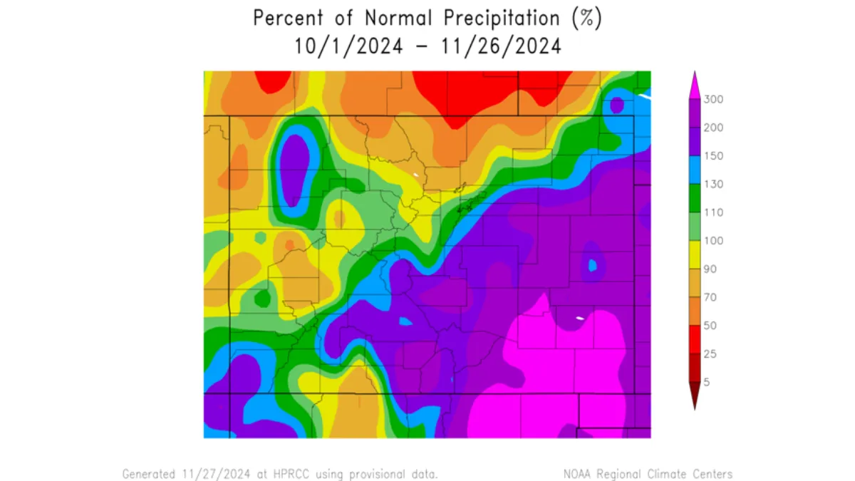
An unseasonably warm summer and fall gave way to significant November snowfall, which has alleviated drought conditions in parts of Colorado, especially in the southeastern corner. The early November storm, which began on Election Day, set a 30-year snowfall record on Pikes Peak and delivered several feet of snow to the lower Arkansas Valley and parts of the eastern plains. Trinidad received an extraordinary 43 inches of snow.
In some southeastern communities, the storm brought precipitation levels well above what is typically expected from November through February, according to Russ Schumacher, Colorado’s state climatologist. For many, this storm was surpassed only by one in 1946. Baca and Prowers counties, located on the state line, saw their drought classification improve from severe to abnormally dry—a rare level of improvement from a single weather event.
El Paso County has also shifted from moderate drought to abnormally dry conditions, according to the U.S. Drought Monitor. Statewide, land categorized as in drought dropped from 52% in October to 42%, according to Brad Pugh, operational drought lead at NOAA’s Climate Prediction Center. Pugh anticipates no new drought development through February.
The snowstorm just before Thanksgiving brought additional precipitation but has not yet been included in drought assessments. Schumacher noted that some areas received over an inch of water from the storm. “For any time of year, this is a very big storm,” he said.
However, Colorado’s critical snowpack, vital for water supplies year-round, typically builds later in the season. Water providers are optimistic, as the early snow offers a promising start. The Nov. 4 storm broke 30-year records for November accumulation on Pikes Peak, with the North Slope receiving 29 inches (259% of the average) and the South Slope 44.3 inches (311% of the average), said Nick Harris, an engineer specializing in water resource planning. Overall, local watersheds are at 106% of their average water levels for this time of year.
Denver Water, which serves 1.5 million metro-area residents, reported strong early-season numbers, with snowpack at 120% of the median on the South Platte River and 104% on the Colorado River. “It’s been one of the better starts to the season that we’ve seen,” said Nathan Elder, Denver Water’s manager of water supply, noting the last similar start occurred in 2019.
The heavy, wet snow arriving before the ground freezes is particularly beneficial, as it helps recharge soil moisture and ensures more water reaches streams and rivers in spring.
Despite the promising start, the coming weeks are forecast to be warm and dry across much of Colorado, particularly in the south. The state’s snowiest months, including March, lie ahead, leaving the long-term outlook uncertain. “There is still a long, long winter yet to go,” Schumacher said.

