The Northwest US is bracing for another storm this week, which will bring heavy rain, strong winds, and snow in the mountains. Experts are warning that there is a high risk of river flooding, avalanches, and mudslides.
AccuWeather experts are warning that the Northwest U.S. will continue to experience a tumultuous weather pattern in the coming days. The region will be impacted by an atmospheric river, which will bring moisture into Washington, Oregon, Idaho, and western Montana. This will result in heavy rain, strong winds, and high-elevation snowfall. As the weekend comes to a close, another storm is expected to move into the area, bringing another round of flooding rain and adverse weather conditions.
Another round of soaking rain on the way
This Article Includes
Communities along the Washington and Oregon coastline have already experienced significant rainfall since Saturday as the first storm moved into the region. Some areas have received 2-3 inches of rain, with a few locations even surpassing the 4-inch mark by Sunday morning. Meteorologists predict that more rain is expected as a secondary storm strengthens and approaches the coast.
Some areas along the Northwest coast are expected to receive more rainfall in just two days than they have experienced throughout the entire month.
According to AccuWeather Meteorologist Jacob Hinson, the Pacific Northwest is currently experiencing an active atmospheric river pattern, leaving little room for respite. This advancing storm has intensified quickly offshore, further saturating the already drenched region with additional rainfall.
“By the time the early week storm is done, total rainfall will rise to 3-8 inches from both storms in lower areas and greater than 16 inches in mountainous terrain. As a result, concerns for river flooding remains high, especially with the previous week’s snow melting and contributing to runoff,” added Hinson.
Stormy pattern can spark avalanches
Forecasters are not only concerned about the heavy rainfall affecting the coastal and foothill regions but also highlighting the significant avalanche risk across the Washington Cascades in the coming days. The combination of intense rain and weakly packed snow on sloped areas could lead to avalanches from higher elevations to the valley floors. Given the stormy conditions, it is strongly advised for hikers to avoid venturing out. Although the highest risk is expected on Sunday, some locations may experience a lingering high risk into early next week.
More snow is anticipated as the next storm moves into the area on Monday, especially over the Cascade Range.
“In the foothills of the Cascades, fresh rainfall totals can surpass 2 inches by Monday evening before the changeover to snow occurs between 3,000-4,000 feet. Snow levels will fall throughout the day on Monday before rising again on Tuesday, with Monday night providing the best chance for snow in the lower passes, like Snoqualmie Pass,” noted AccuWeather Meteorologist Emma Belscher.
“Sting jet” can produce fierce winds
AccuWeather meteorologists have issued a warning that as the storm intensifies and batters the Northwest Coast on Monday, there is a potential for an atmospheric phenomenon known as a ‘sting jet’ to occur.
Since the early 2000s, the term “sting jet” has been gaining popularity in the United Kingdom. It refers to a meteorological phenomenon characterized by a small area of strong winds that can cause significant wind damage. When observed on weather satellites, this formation resembles a bee’s stinger or a scorpion’s tail. The term “jet” is derived from the jet stream, which is a high-speed air current located in the upper atmosphere.
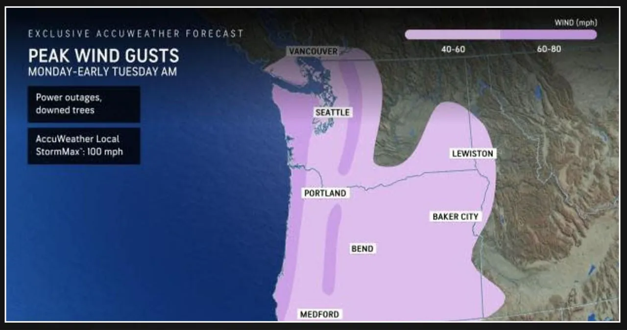
According to Hinson, as this low pressure system rapidly strengthens, it will bring extremely strong wind gusts that run parallel to the coasts. Along the coast, locations just inland and along the mountaintops, we can expect gusts of 60-80 mph. In more sheltered cities like Seattle, gusts around 40-60 mph can be observed.
According to AccuWeather, the Local StormMax™ indicates that the peak wind gusts can reach up to 100 mph.
According to Hinson, the strongest gusts are expected along the Washington-Oregon border, where there is a potential for even stronger winds due to a possible sting jet. This weather event is likely to cause wind damage, including power outages and fallen trees, until Tuesday morning.
By Tuesday afternoon and evening, the stormy weather is predicted to diminish across the Northwest. The strong winds will gradually subside and the rain will stop in the area, resulting in mostly dry conditions for the rest of the workweek.
Heat intensifies in the Southwest
Residents in Southern California to New Mexico can expect a significant change in the weather this week. Temperatures are set to increase across the Four Corners and Desert Southwest regions, with some areas even reaching the 90-degree mark for the first time this year.
By midweek, temperatures in locations such as Phoenix and downtown Los Angeles could reach 90°F, posing a potential risk.
By Wednesday, there is a possibility that some areas might tie or even break their daily temperature records.