An ice storm is predicted to strike the Midwest and Northeast by mid-week, posing a significant risk to at least six states.
Why It Matters
This Article Includes
Widespread freezing rain is set to cause disruptions from the Midwest to the Mid-Atlantic starting on Wednesday. Meteorologists from the National Weather Service (NWS) have cautioned about the hazardous travel conditions resulting from the sleet and freezing rain affecting roadways. Residents in the affected areas are advised to stay informed about the forecasts, particularly if they have travel plans during the storm.
What to Know
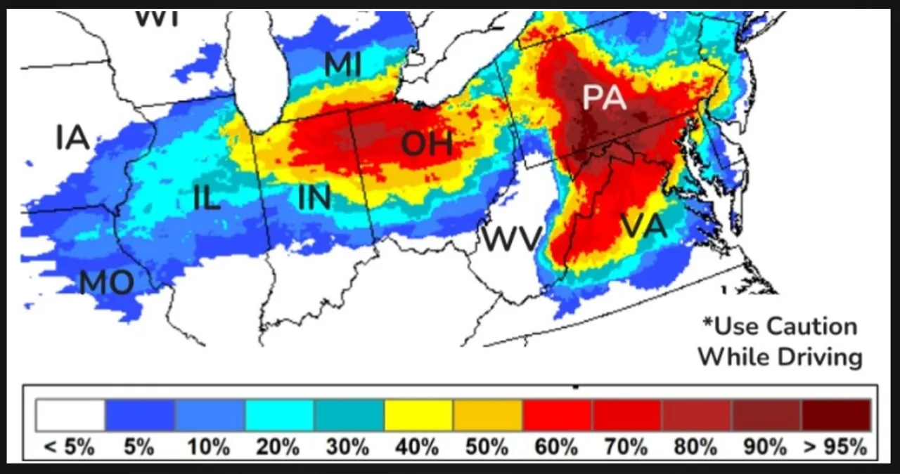
The National Weather Service (NWS) Weather Prediction Center issued a crucial message on Monday regarding the approaching storm. Alongside the forecast, they provided a map highlighting the states that would be most affected by the freezing rain.
According to the forecast, the areas most likely to experience heavy icing are western Maryland, the West Virginia panhandle, and parts of Pennsylvania. Surprisingly, the map also indicates a high risk of ice in northeast Indiana and northwest Ohio.
Meteorologists are cautioning about the potential for scattered power outages and tree damage as a result of the ice storm. Although lighter amounts of ice are anticipated in the Midwest, Great Lakes, and Mid-Atlantic regions, meteorologists have emphasized that even freezing rain below 0.25 inches can still pose hazards.
Weather alerts and warnings have already been issued across Pennsylvania, West Virginia, and Maryland as of Tuesday afternoon. The most widespread alert is a winter weather advisory, but there is also an ice storm warning and a winter storm watch in effect.
According to meteorologist David Roth from the NWS Weather Prediction Center, the most important precaution to take during an ice storm is to stay indoors and avoid using roads and sidewalks. He emphasized that the storm poses significant risks to transportation, as well as potential damage to tree branches and power lines.
What People Are Saying
According to the NWS office in State College, Pennsylvania, a warning has been issued for an ice storm. The warning states that there will be significant icing, which is expected to occur late Wednesday night and into Thursday morning. The ice accumulations are predicted to be between three and five tenths of an inch, resulting from freezing rain. Before the freezing rain, there may also be some accumulation of snow and sleet, which is estimated to be an inch or less.
The advisory stated, “It is strongly advised to avoid traveling. However, if you really need to travel, make sure to keep an additional flashlight, food, and water in your vehicle in case of an emergency. It is also important to be prepared for potential power outages.”
What Happens Next
The ice storm’s impacts are anticipated to persist from Wednesday through Thursday. Moving ahead, the NWS Climate Prediction Center forecasts below-average temperatures and above-average precipitation for the next eight to 14 days in the region.