The Arizona Weatherman predicts that Arizona will experience the next significant weather system from Thursday to Saturday, 13-15 Feb 2025. Unlike the previous systems, this one is coming off the Pacific Ocean farther south and will bring a warmer influx of moisture. The impact will be first felt in California before reaching Arizona, resulting in more moisture. Central and northern Arizona will be the most affected regions, although the valley area and southern Arizona will also experience some precipitation, but to a lesser extent. In this article, we will provide forecasted estimates for the total precipitation in the state during this period.
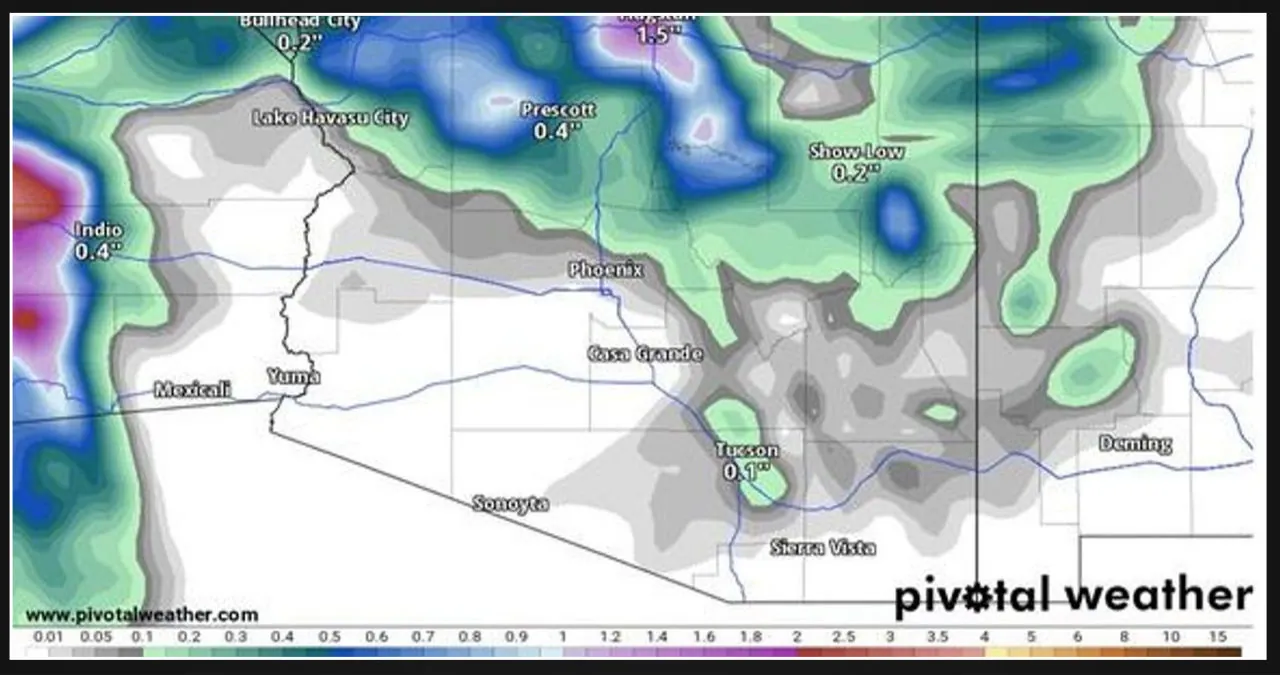
The upcoming weather system will have a greater impact on Mohave, Yavapai, Coconino, and Gila Counties. Flagstaff is anticipating a potential snowfall of 3-6 inches, while the Grand Canyon South Rim might receive 2-5 inches of snow. As this system moves in, the freezing level will rise from approximately 4,000 feet to over 6,000 feet. However, there is significant variability in the models, ranging from low to high snow levels. Considering this, I am making a forecast that falls somewhere in the middle.
In the case of Prescott and Payson, there is a possibility of a mix of snow and rain, but I expect rain to be the predominant form of precipitation during this event. Therefore, for both Prescott and Payson, I am forecasting a water equivalent. They can expect rainfall ranging from 0.20 to 0.70 inches. Similarly, Kingman can anticipate rainfall between 0.30 to 0.70 inches. However, in the valley and lower elevations, the amount of precipitation expected is relatively less.
For Phoenix, a rainfall of 0.10 to 0.40 inches is anticipated, while Tucson can expect 0.10 to 0.40 inches. Lastly, Benson is likely to receive rainfall between 0.05 to 0.25 inches.
On Thursday and Friday at the Mogollon Rim, the wind will also play a significant role. From Show Low to Flagstaff and the northern parts of the state, we can expect wind gusts of 30-45 mph. This combination of wind and snow might make driving on I-40 a bit challenging during those days. If you are traveling on the interstate with high-clearance vehicles, please exercise caution. Let’s hope that this event brings more snow and rain to Arizona compared to the previous ones. Stay safe!
The forecast provided is from an experienced meteorologist known as The Arizona Weatherman. With over 25 years of experience in aviation meteorology, government contracting, and private practice, his expertise is highly regarded. He has also trained Special Operations Weather Technicians (SOWT) in weather techniques and is a certified STEM teacher. Rest assured, his weather predictions are reliable.